
Secret beaches in Oregon sit just off Highway 101. Tucked behind unmarked trails, screened by walls of spruce most drivers blow right past without a second glance. Meanwhile tourists pile onto the boardwalks at Cannon Beach and Seaside, elbow to elbow, while people who’ve called this coast home for decades slip down unsigned paths to coves where the only footprints belong to them. I’ve spent years chasing these places down – trading tips with park rangers, watching tide charts like a hawk, showing up at strange hours just to catch the light right – and this guide is everything that work turned up.
363 miles of shoreline. That’s Oregon’s coast, and a surprising chunk of it sits empty most days. No permit. No guide required. Just the right pullout, a tide table in your back pocket, and a willingness to walk.
Here’s the real list. Where these beaches hide, how you actually get to them, what makes each one worth the trip, and the safety details that matter more than anything else on this page.
Why So Many of Oregon’s Best Beaches Go Unnoticed
Oregon has something most coastal states simply don’t have: every inch of its 363-mile shoreline is legally public, guaranteed since the 1967 Beach Bill. So when a beach here stays hidden, it’s not because somebody fenced it off. The landscape does the hiding on its own.
Steep bluffs. Trails with no signage at all. Turnouts that look like nothing more than a gravel shoulder to anyone driving by at fifty miles an hour. That’s the formula. You’ll typically find hidden beaches in Oregon:
- Tucked below a headland with no official lot to park in
- At the end of a trail nobody ever bothered marking
- Hidden from the highway behind thick stands of Sitka spruce
- Inside a well-known state park, overshadowed completely by whatever feature gets all the Instagram attention
That last one explains more than people realize. A lot of these secret beaches in Oregon aren’t secrets in any real sense – they’re just standing in the shadow of something more famous a quarter-mile up the trail.
The Oregon Beach Bill: The Law Behind the Access
Oregon’s public beach law keeps the whole coastline open, from the waterline to wherever the vegetation starts. Few states bother with this. Most let private owners claim the beachfront and lock everyone else out, full stop. Not here. That’s the entire reason an ordinary visitor – not somebody with a beach house and a private gate – can still wander into a cove and have the whole thing to themselves.
The Best Secret Beaches in Oregon Worth Tracking Down
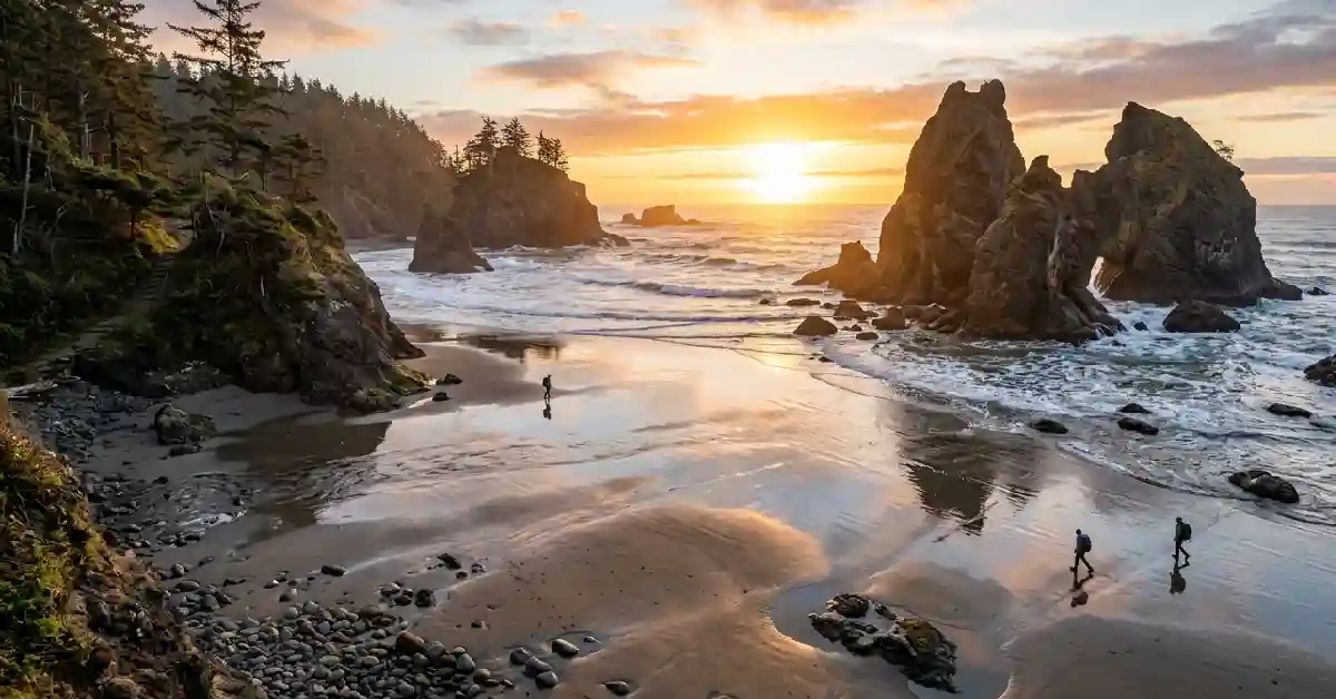
Secret Beach, Samuel H. Boardman State Scenic Corridor
This is the one that gave the whole idea its name. It sits inside the 12-mile Samuel H. Boardman State Scenic Corridor, somewhere between Brookings and Gold Beach, and what it hands you is hard to overstate: sea stacks rising straight out of the surf, a cove so tight it feels private, scenery that genuinely doesn’t look real the first time you see it.
Getting there:
- Pull off at an unmarked spot along Highway 101. Other parked cars are usually your only clue you’re in the right place.
- Follow the short trail through spruce and salal.
- It drops steeply down into a small, sheltered cove.
When to go: Early morning, or right around sunset. Time it close to low tide so you’ve got more sand underfoot.
Locals who do pass this one along rarely do it loudly. Usually it’s a quiet word, and only to someone they trust not to leave trash behind.
Must Read: The Honest Guide to Family Friendly Vacations in California
Hug Point, South of Cannon Beach
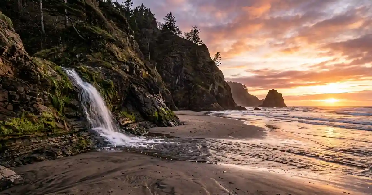
Five miles south of Cannon Beach. That’s where you’ll find Hug Point, named for the old coastal road that forced travelers to literally hug the cliffside at low tide, back before Highway 101 even existed. It pulls a fraction of the crowd its famous neighbor does, despite being every bit as striking.
Why it’s worth the stop:
- Sea caves that only reveal themselves at low tide
- A small waterfall pouring straight onto the sand
- Wagon-wheel ruts from the 1800s, still carved into the rock and visible today
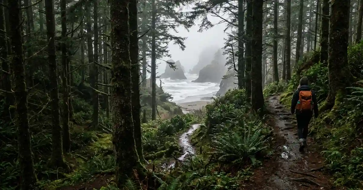
Short Sand Beach (“Shorty’s”), Oswald West State Park
Locals just call it Shorty’s. A short walk through old-growth forest inside Oswald West State Park gets you there, and because the cove’s shape blocks most of the wind, it stays noticeably calmer than the open beaches farther north – sometimes by a wide margin.
Cove Beach (Magic Rocks Beach), Arch Cape
Between Cannon Beach and Manzanita, hiding inside an ordinary residential neighborhood near Richmond Street and Tide Road. A simple staircase drops you onto a stretch of smooth, rounded cobblestones. Locals nicknamed it Magic Rocks Beach for the sound those rocks make – a clattering, tumbling noise – when high tide rolls through.
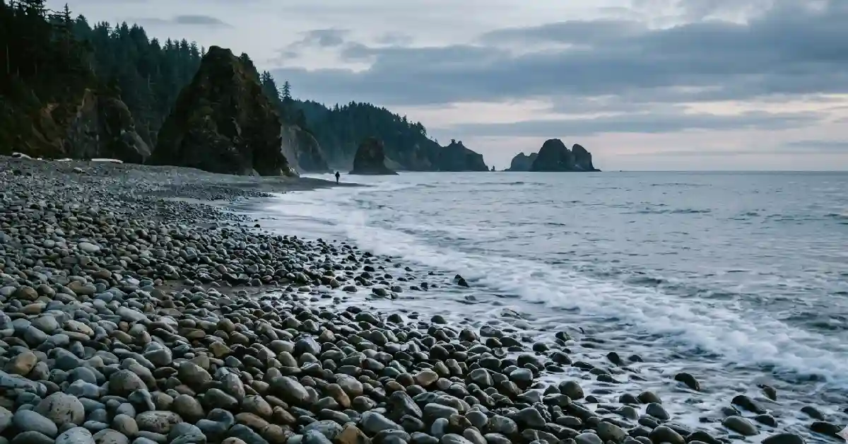
Tunnel Beach, Bandon Area
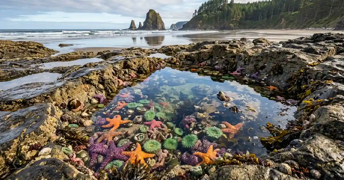
Tunnel Beach sits near Coquille Point, connected to the Oregon Islands Wildlife Refuge, where seabirds and seals and a healthy stretch of tide pools all share the same shoreline. Get there early. Time it with low tide. You’ll likely have the place nearly to yourself.
What You Gain by Skipping the Crowded Beaches
Choosing a quieter spot over the usual tourist stop pays off in a few specific ways.
- More wildlife, fewer people. Seabirds, harbor seals, and tide pool creatures tend to steer clear of the beaches everyone else floods to on a sunny Saturday.
- Photos without strangers wandering into frame. Soft light filtering down through the trees. Sea stacks with nobody standing in front of them, ruining the shot. It’s a different kind of photography entirely.
- An actual sense of discovery. There’s a particular feeling – walking a forest trail, then stepping out into an empty cove – that a parking lot full of cars just can’t replicate.
- Less wear on the land, assuming people behave themselves. Smaller crowds usually mean less erosion and less litter. Usually. It depends entirely on whether visitors stick to Leave No Trace habits.
Must Read: Plan the Perfect San Diego Zoo Safari Park Tours Package
What You’re Trading Away
These beaches aren’t perfect, and it’s worth being honest about that upfront.
- No amenities, period. No restrooms. No lifeguard. Often no cell signal either, so plan accordingly.
- Harder to reach than a parking-lot beach. Steep, unmarked trails rule out strollers, small children, or anyone who struggles on uneven ground.
- The tide controls everything. A lot of these beaches disappear entirely once the water comes in – and that can trap you on the wrong side of a headland if you’re not paying attention.
- Help is farther away. Something goes wrong out here, and you’re not standing next to a developed beach with quick access to assistance.
How Locals Actually Find These Spots
No secret formula, honestly. Just habits that work, repeated often enough that they become instinct.
- Pull up satellite imagery first. Google Earth shows coves and inlets that never make it onto a standard road map.
- Pay attention to the wording in map listings. Tags like “natural area,” “state recreation site,” or “viewpoint” often sit right next to an unmarked beach trail – that phrasing is rarely an accident.
- Watch for blank turnouts along Highway 101. No sign doesn’t mean nothing’s there. Usually it just means there’s a worn path heading into the trees.
- Ask someone who actually lives there. Coffee shop staff, surf shop owners, trailhead regulars in towns like Yachats, Gold Beach, or Pacific City – they usually know which cove is quiet that particular week, and they’ll tell you if you ask nicely.
- Never, ever skip the tide chart. A beach that looks perfectly reachable on a map this morning can be completely underwater by afternoon.
Build Your Trip Around the Tide
People who know this coast well don’t drive up and hope for the best. They plan the entire visit around a tide chart, down to the hour. The rule of thumb goes like this: arrive roughly an hour before the lowest tide, while the water’s still pulling back, and start heading out the moment it turns. One habit. That’s all it takes to avoid the mistake that catches almost every first-timer off guard – getting boxed in by rising water around a headland with nowhere left to go.
What You Need to Know Before You Go
Most guides to hidden beaches skip this part. This one won’t, because it might be the most important section on the entire page. Oregon’s coves are stunning, genuinely. But this is not the gentle, swimmable Pacific people picture after a trip to California.
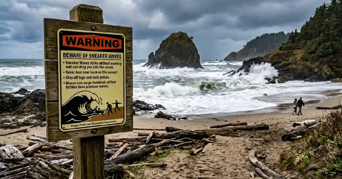
Sneaker waves top the list of real dangers, by a wide margin. These are sudden surges capable of shooting far past the normal waterline – with enough force to knock a grown adult clean off their feet – and they frequently drag logs heavy enough to cause real injury along with them. As recently as this year, the National Weather Service issued sneaker wave warnings along this exact stretch of coast, with officials telling people to stay clear of jetties and rocks entirely, and to never, under any circumstances, turn their back on the water.
Rules worth memorizing, not just reading once:
- Never turn your back on the ocean. Even when it looks completely calm. Especially then, actually.
- Keep away from driftwood logs near the surf – even the small-looking ones can weigh tons once they’re waterlogged.
- Stay off jetties and rock outcrops whenever the tide is coming in.
- Caught in a rip current? Swim parallel to the shore, not against the pull, until you break free of it.
- Pull up tide charts and beach hazard alerts before you ever leave the house.
- Three to five people die on Oregon’s north coast every single year. Sneaker waves, cold-water shock, or someone going into the surf after a panicking dog. Don’t follow your dog into the water – they almost always make it back to shore fine on their own.
Cold water brings its own separate risk, apart from the waves themselves. The Pacific here can trigger cold-water shock and leave your muscles unable to respond within minutes – which is exactly why most of these beaches work far better for wading and tide pooling than for actual swimming.
Must Read: New Mexico Tour Packages: Your Ultimate Guide to the Land of Enchantment
A Note From Someone Who’s Watched This Happen Before
I’ve watched a quiet cove lose everything that made it special in a single season, the moment one photo of it took off online. It happens fast. The beaches that hold up over years, not just one viral summer, are the ones people treat with some care.
- Carry out everything you bring. Food scraps included, no exceptions.
- Leave the rocks exactly where they are – tide pool life depends on that habitat staying undisturbed.
- Stick to trails that already exist instead of cutting new ones through fragile bluffs.
- Skip tagging the exact coordinates publicly. Naming the general area is plenty.
This isn’t about keeping people out, not really. It’s about making sure these places are still worth finding when the next person stumbles onto them, ten years from now, the same way you did today.
Conclusion
Secret beaches in Oregon reward a particular kind of traveler – the kind willing to check a tide chart, follow a trail with no sign on it, and treat the coast the way locals actually do. The sea stacks at Secret Beach inside the Boardman Corridor. The sea caves at Hug Point. The rocks clattering along the shore at Cove Beach. Each one offers something the busy, crowded beaches simply can’t match. Show up prepared. Plan around low tide. Keep your eyes on the water at all times. Do that, and you’ll understand pretty quickly why locals have held onto these spots for as long as they have.
FAQ
What are the best secret beaches in Oregon?
A few stand out: Secret Beach in the Samuel H. Boardman State Scenic Corridor, Hug Point near Cannon Beach, Short Sand Beach in Oswald West State Park, Cove Beach in Arch Cape, and Tunnel Beach near Bandon. Each one offers a quieter alternative to the more crowded stops along the coast.
Are Oregon’s hidden beaches free and open to the public?
Yes, all of them. Oregon’s 1967 Beach Bill guarantees public access to the entire 363-mile coastline, so even the most secluded coves stay legally open – no private ownership ever stands in the way.
How do I find unmarked beach access points in Oregon?
Watch for unsigned turnouts along Highway 101. Study satellite imagery on Google Earth. Look for map listings tagged “natural area,” “viewpoint,” or “state recreation site” – that wording usually means something’s nearby. And don’t be shy about asking locals in towns like Yachats or Gold Beach; they often know exactly where to send you.
Is it safe to swim at hidden beaches in Oregon?
Mostly, no – not for actual swimming. These beaches work better for wading, tide pooling, and photography. Cold water can bring on shock and muscle paralysis within minutes, and sneaker waves strike without warning, so swimming isn’t recommended at the majority of these spots.
When is the best time to visit secret beaches in Oregon?
About an hour before low tide is ideal, while the water is still pulling back and trails and tide pools are at their most exposed. Always check the local tide chart and any active beach hazard statements first – every single time, no exceptions.